Mozambique: A New Bridge & A New Road Brings Limited Vitalisation of the Far South
The unlocking of a unique tourism area and a new cross-border trade route…
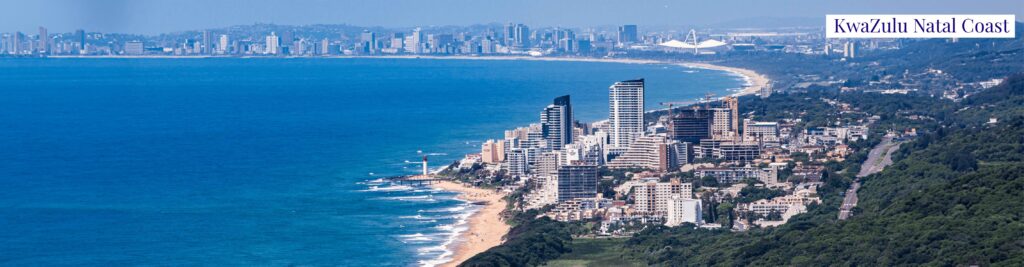
It was 2017 when my colleague, Roelof and I visited Maputaland. This area encompasses the far north of the KwaZulu-Natal coast, spreading all the way up to Katembe town just south of Maputo City in Mozambique. This coastal strip is sandwiched between the Ubombo Mountains and eSwatini in the west and the Indian Ocean in the east. It is a unique tropical world of wide beaches and lagoons, fish kraals, lala palms and fine sand everywhere. (Including one’s ears, nose, mouth and other places!). Apart from the well-frequented tourist beach resorts, Maputaland is sparsely populated.
I have been visiting Maputaland since the mid-1970’s and even attempted a university masters thesis on the history of this intriguing coastal land.
The main reason why Maputaland has been under-developed and why it is generally so under-populated, is its poor soil quality and consequently, limited scope for agriculture.
Studies undertaken in the 1990’s indicated a population of 29 persons per square kilometre over an area of roughly 10 000 square kilometres and about 200 000 inhabitants. The population densities vary considerably with higher rates in the areas just south of Maputo, the South African border, the Jozini Lake and in the far south in Saint Lucia. Commercial forestry has been attempted, and fishing is a major subsistence activity. The fibrous plant used to make rope, sisal was planted, mainly to reinforce land boundaries.
There is one Maputaland agricultural product that deserves mention – the famous (infamous?) lala palm wine. During a visit to the border town of Manguzi on the South African side, my travelling companion and I asked a taxi driver to take us to a local shebeen for our first taste of this local nectar. I took one sip of the murky brown liquid from the old Coke bottle. It tasted like battery acid and burned its way right down through my innards. My companion took the smallest sip possible, had a mild convulsion and spent five minutes spitting out the remnants of his timid attempt.
The Mozambican and South African governments have largely neglected development of this piece of paradise. The roads in the Mozambican section are particularly sandy and 4×4 vehicles have for long been the only means of travel. (Of course the 4×4 enthusiasts love the tough driving challenge.) The road on the KZN side leading up to the border near Kosi Bay is tarred and in surprisingly good condition. There has been much talk of the establishment of new ports also in the Mozambican section. However, the area is very environmentally sensitive and the proposed export of coal from Botswana through these sea outlets would be damaging. This is probably a reason why port developments have not materialised to date.
A mission to investigate two major transport developments…
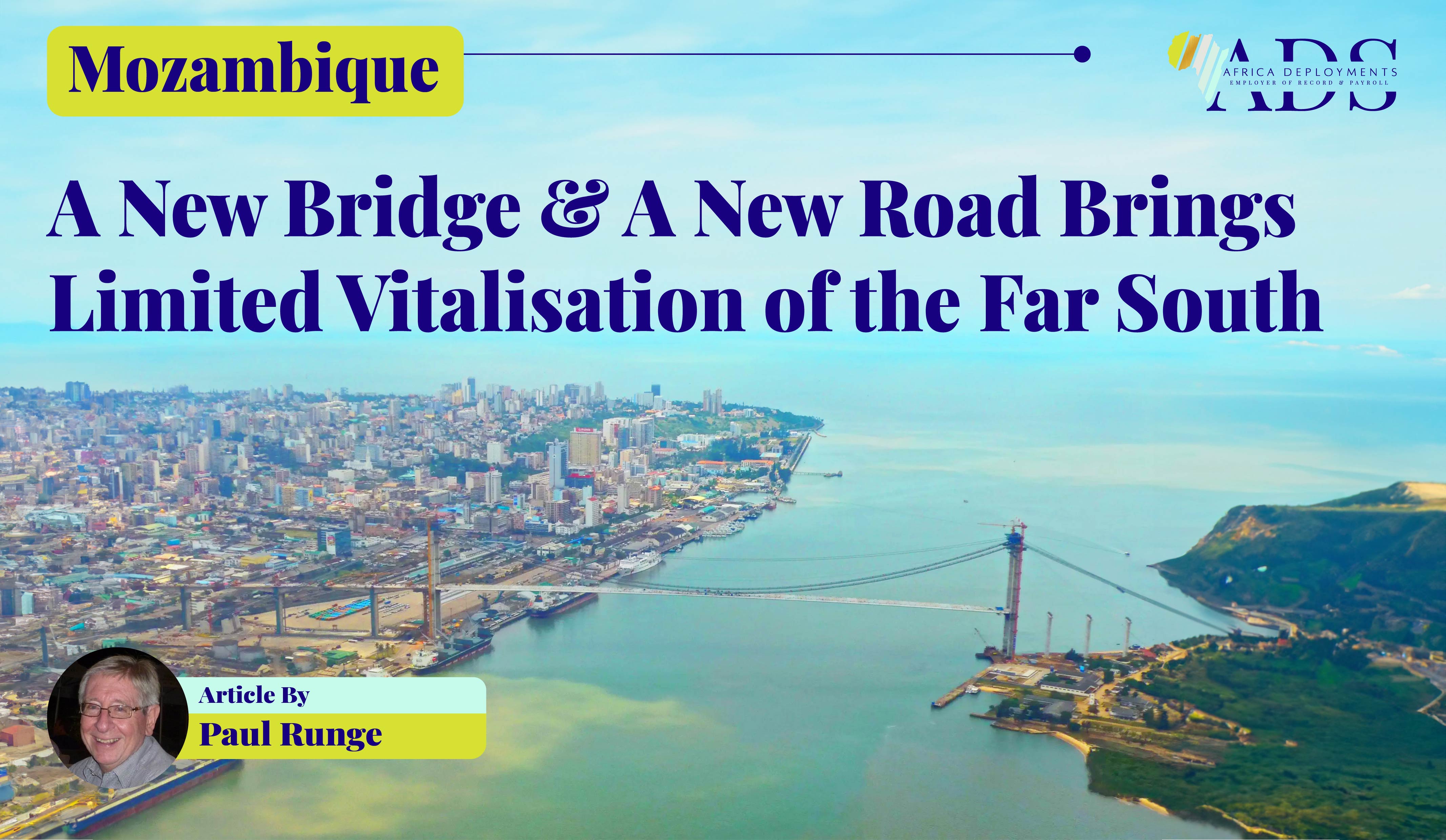
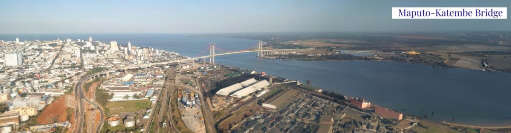
We were on a mission to review the progress of construction of the new 110-kilometre tar road from Katembe town south of Maputo city to the Kosi Bay KZN border, as well as the status of the four-lane, three-kilometre suspension bridge from the city across Maputo Bay to Katembe. Both projects were being under taken by the China Road and Bridge Corporation.
The road traversed a large area of swampland and required culverts and river bridges. We were impressed with the standard of work on the completed tarred sections. The road was wide and constructed on embankments to ensure effective water drainage in this often flood-ravaged coastline. We encountered little traffic.
The three-kilometre, four-lane Maputo-Katembe Bridge was underway – an impressive feat, as the longest suspension bridge in Africa. Today, its height is some 60 metres to allow ships to pass under. The bridge was built to replace the busy, chaotic, and slow passenger and vehicle ferry that travellers had for so long been compelled to use. The final cost of the bridge was US$ 785 million.
Some developments, but limited economic benefit from the new transport corridor…
The new road and bridge were officially opened in 2018 and reduced land travel between Maputo and KZN to only two hours. Road travel from the Kosi Bay border to the major South African port of Richards Bay is less than four hours further. An effective six-hour trade corridor between the two major southern African ports had been created.
But what economic benefits have accrued from this greatly improved transport infrastructure?
At the time of our mission, South African border officials informed us that 300 to 400 vehicles were crossing per day. This traffic between Maputo and the border has certainly increased substantially since then, (although it is difficult to obtain the relevant statistics.)
Increased tourism is an obvious benefit. Residents of Maputo City are now visiting the coastal lodges and resorts. There has been a marked increase in the number of these holiday facilities as well as large private beach homes. Ponta do Ouro (close to the border,) has long been a favourite for pleasure-seekers arriving from South Africa, but has grown with the additional influx of visitors from further north. There are also new beach lodges on Machangulo Peninsula situated opposite Inyaka Island.
Eighty kilometres south of Maputo is the Maputo Special Reserve (previously called the Maputo Elephant Reserve). A few ecotourism investments have been made there and it is now linked to the Tembe Elephant Reserve in KZN through the protected Futi Corridor.
However, the expected flood of investors, developers, and tourists has yet to occur.
Further road development is required. The ancillary roads leading to and within resorts such as Ponto do Ouro and Ponto Malongane need to be tarred.
Upgrade of the Kosi Bay border post has not occurred although there are reports that the South African Revenue Services is considering the establishment of a customs office there.
Tourism and commerce will be enhanced by improvement of these ancillary, feeder roads. A road linking Maputaland to eastern eSwatini has been mooted. This link would facilitate the East3 Tourism Initiative agreed upon by the three partner countries.
A major planned project is the Katembe City. The Mozambican authorities are promoting it as an upmarket development that will take advantage of its proximity to Maputo by drawing the well-heeled from that city.
There have been some hotel and residential developments in Katembe, but large-scale development is still awaited.
As we approached Katembe, during our mission, we came across the construction site of the Chinese road and bridge contractor – a concrete product manufacturing plant, and a cement plant with a crusher.
Recent visitors to this area report that activity at these industrial sites is minimal. The prospect of a thriving industrial zone has yet to be realised.
Upon return from the mission, I submitted a proposal to the KZN Economic Development, Tourism and Environmental Affairs Department for collaboration on a business conference on Maputaland. I suggested that this event focus on the following projects: an ancillary feeder roads programme, upgrade of the Kosi Bay border post, linkage of Maputo and Richards Bay, and new border access into eastern eSwatini. I also proposed investigation of the development of Manguzi town into a supply hub for South African products into Mozambique. (The town is conveniently situated in South Africa close to the Kosi Bay border. )
No reply to my enthusiastic proposal was received from the KZN department.
Can the supply of liquefied natural gas from Mozambique though Maputaland become the catalyst for development of Maputaland?…
Mozambique is endowed with huge LNG resources and South Africa needs LNG as an alternative power generation source. There are the three major LNG projects in Cabo Delgado in the far north, and in the centre of the country, the Pande and Temane fields are still producing. SASOL has recently announced a new onshore find in this area.
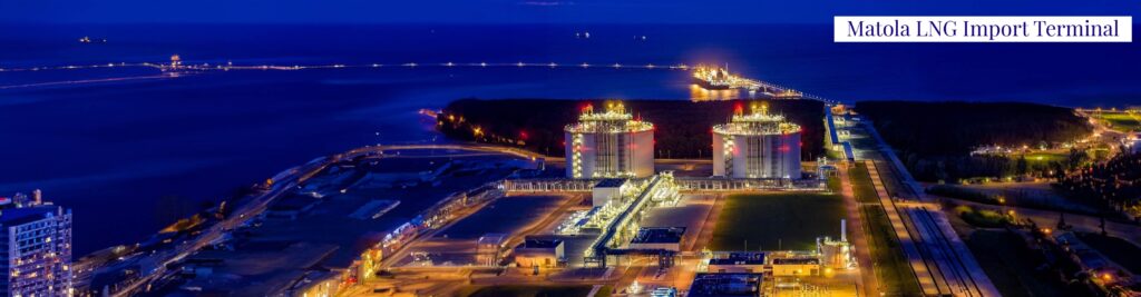
The Matola LNG Import Terminal Project near Maputo is drawing considerable interest. A Floating Storage and Regasification Unit will be moored at the site. A main objective is to supply LNG to South Africa. The project plans include an LNG truck-loading facility for transport of production by road.
Could the Maputaland road route not be utilised for this gas supply? It would seem logical given that Richards Bay Port has been declared a gas collection hub? How would this choice vitalise Maputaland? We’ll just have to wait and see.